Geomatics & Modeling
Woodlands utilizes the power of GIS and predictive modeling to make smarter, data-driven decisions for natural resource management. Our expert solutions help you analyze spatial data, forecast environmental changes, and optimize resource planning with precision. Whether it's land use optimization, climate impact assessment, or habitat suitability modeling, we deliver actionable insights to drive sustainable outcomes.
Let’s turn data into strategy—empower your projects with cutting-edge geospatial analytics today!
Services include:
Habitat suitability & biodiversity analysis
Wildfire hazard assessment and predictive post-fire debris flow
Decision support system development
Geospatial machine learning
Web & mobile GIS applications
Bridge & crossing inventory
GPS & drone-based Surveying
Q50 & Q100 watercourse flow calculations
3Q10 watercourse flow calculations
Geospatial data integration (LiDAR, UAV, IoT)
Change detection & time-series analysis
Satellite & aerial imagery analysis
TDA modeling and post field cruise validation
RPAS system data capture for volumetric modeling
3D modeling and site/scene fly-throughs
Volumetric modeling of log decks, chip piles, remote yards
Terrain & elevation modeling
Viewshed analysis
-
![]()
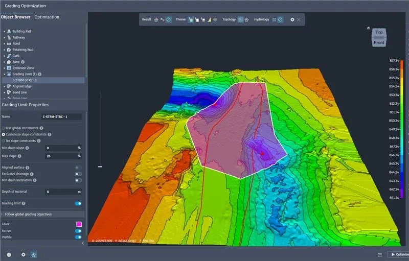
3D grading optimization using hydrogeotechnical and topographical data to create the road-ditch run-off plans at a watercourse crossing.
-
![]()
HEC-RAS hydraulic modeling of a watercourse
-
![HEC-RAS hydraulic modeling of a watercourse]()
HEC-RAS hydraulic modeling of a watercourse
-
![]()
Orthomosaic and Digital Surface Model of a watercourse crossing captured from RPAS/drone
-
![]()
HEC-RAS modeling depicting the hydraulics of water flow under a bridge
-
![]()
Watershed Delineation and Q-Value calculation to determine the minimum watercourse crossing size